



- A real-time tracking on-demand app needs WebSocket, geofencing, and a message queue; not just a map API.
- Standard GPS polling updates every 10 to 30 seconds. Real-time push architecture updates every 3 to 5 seconds.
- Build cost starts at $35,000. Monthly infrastructure adds $200 to $5,000 depending on user volume.
- Firebase works for MVPs under 50,000 connections. Custom backends with PostGIS handle geographic queries at scale.
- iOS background mode restrictions and GPS drift are the two most common reasons tracking fails after launch.
- TekRevol has shipped live tracking across food delivery, logistics, and field service platforms.
Integrating a live tracking GPS into a mobile app is not just linking it to Google Maps. A real-time tracking on-demand app needs WebSocket to ensure data flow, a message queue for handling updates, geofencing to know live location, and ETA calculations; all working together smoothly.
And let’s be real, people want this. According to a survey by Anyline, 96% of customers find GPS tracking helpful when they’re waiting on a delivery. They are not checking it once. They are watching the driver on their screen. Miss that window, and the experience feels broken, even when everything else works perfectly.
If you are planning on-demand app development, the tracking architecture is the decision that shapes your entire stack. At this stage most founders run into budget surprises and delayed rebuilds. This guide covers the real-time location tracking app development process, costs, and how to choose a team that has shipped this at production scale.
What a Real-Time Tracking On-Demand App Actually Does
Each one handles a different job, and each one has to work for the experience to feel seamless.
1) Customer-facing live map
Your customer watches the driver move toward them. The pin updates without a screen refresh, without the customer doing anything.
2) Operations dashboard
Your team sees all active drivers at once. When a driver stops moving, they see it immediately. They can reassign, reroute, or call the driver before the customer even notices a delay.
3) Driver-side broadcast
The driver’s phone sends GPS coordinates to your server every few seconds. Your server processes those coordinates and broadcasts them to both the customer map and the ops view at the same time.
Most on-demand apps launch with Layer 1 only. With 30 active drivers, you need Layer 2. At 100 drivers, Layer 3 needs to be optimized for high-frequency writes, or the backend shows the strain. Our mobile app development services cover building all three layers across platforms.
Not Sure Which Layers Your App Needs at Launch?
Consult with TekRevol. We map your driver volume, protocol, and Phase 2 roadmap.
Book Your Free Scoping Session →How Real-Time Tracking Different From Standard GPS Apps
Standard GPS apps and real-time tracking apps look identical from the outside. Under the hood, they work completely differently. The table below captures what separates them.
| Factor | Standard GPS App | Real-Time Tracking On-Demand App |
| Update method | HTTP polling. App requests a position every 10 to 30 seconds | Push architecture. The server sends updates the instant a driver moves |
| Update frequency | Every 10 to 30 seconds. Map pin jumps | Every 3 to 5 seconds. The map pin moves smoothly |
| ETA behavior | Set at order placement. Goes stale between polls | Recalculates continuously as the driver moves |
| Connection type | Stateless HTTP. Opens, responds, closes | Persistent WebSocket. Stays open for the trip |
| Backend requirement | Standard REST API handles it | Persistent socket layer holding thousands of open connections |
| Database requirement | Standard relational database | Geospatial database with spatial indexing. |
| Queue requirement | Not needed | Required to absorb simultaneous pings |
| Baseline build cost | $8,000 to add to an existing app | $35,000 to build a live data pipeline |
Live tracking is no longer a differentiator. It is an expectation. The question is whether your backend can actually support it under load.
5 Core Components of a Real-Time Tracking On-Demand App
These five live tracking features are not independent; they form a chain. The connection protocol feeds the backend. The backend feeds the map. The ETA engine reads from the backend and sends it to the map. The message queue holds the whole chain together under pressure.
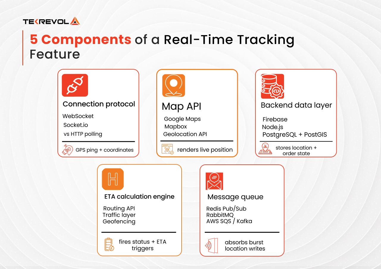
1. Connection Protocol: WebSocket vs HTTP Polling
The WebSocket layer keeps a persistent connection open between your real-time tracking on-demand app and your server.
Traditional HTTP requests create a new connection, asking the server, “Any updates?” every few seconds. WebSocket flips the model. The server pushes new coordinates the moment they change.
At 1,000 concurrent active users, 5-second HTTP polling generates around 12,000 server requests per minute. Socket.io over WebSocket keeps 1,000 persistent connections open and pushes only when data changes. Your server handles far less traffic, which means lower infrastructure cost at the same user volume.
| HTTP Polling | WebSocket / Socket.io | Server-Sent Events | |
| Latency | 5 to 30 seconds | Under 1 second | 1 to 3 seconds |
| Server load at scale | High | Low | Medium |
| Build complexity | Low | Medium | Low |
| Best for | MVP under 300 users | Production scale | One-way data feeds |
| Recommended phase | Phase 1 | Phase 2 onward | Specific cases only |
Use HTTP polling if you are launching an MVP with under 300 concurrent active sessions. Switch to WebSocket via Socket.io once you cross that threshold.
One Common Mistake
WebSocket alone is not enough at scale. When hundreds of drivers push location updates simultaneously, you need a message queue between the WebSocket layer and your database to absorb the volume.
2. Map API: Google Maps vs Mapbox vs Native Geolocation
Your mapping frontend renders those updates visually. Google Maps API and Mapbox are the two dominant platforms.
Google Maps API gives you the widest global coverage and the fastest integration. The first $200 of monthly usage is free, which covers roughly 28,000 map loads. After that, pricing scales per API request.
Mapbox costs roughly 40% less at high volume and gives you full control over every visual element of the map. It is the better choice for white-label platforms or for any app where Google Maps API fees exceed $500 per month.
3. Backend Data Layer: Firebase vs Custom Backend
The backend data layer is where the driver coordinates land after leaving the device. How you build this layer determines how well your app holds up as driver count grows.
Firebase Realtime Database is the fastest path to MVP development. It handles high-frequency writes naturally, syncs across clients in near real time, and has a free tier that covers early user volumes.
A custom backend using Node.js with PostgreSQL and the PostGIS spatial extension gives you full control. PostGIS is built for geographic data. It runs queries like “find all drivers within 5 km of this pickup point” in milliseconds.
The approach that works best for multi-role platforms is a hybrid. Firebase handles the location event stream. PostgreSQL handles order state, user records, and payment data. Each system does what it was designed for, and neither gets pulled into territory where it struggles. If you are planning to build an on-demand delivery app, this hybrid architecture decision is worth understanding.
4. ETA Calculation and Last-Mile Visibility
An ETA set at order placement and never updated is a timestamp, not live tracking. Real ETA recalculates every time the driver’s position changes by a meaningful amount.
Accurate ETA needs four inputs: a routing API, a live traffic data layer, the driver’s current speed history, and geofence zone buffers around pickup and drop-off points.
Geofencing is what transforms ETA from a number into an experience. When a driver crosses a geofence boundary near the drop-off point, the system recalculates ETA from the driver’s actual current position. It also fires the status triggers your customers see: “driver arrived,” “order delivered.”
Last-mile visibility means the final segment between the driver and the customer’s location. A driver two minutes away showing as ten minutes means the ETA model is stale. Tight geofence zones around the drop-off address solve this without changing driver behavior.
5. Message Queue for High-Frequency Location Events
A message queue sits between the driver’s GPS ping and your database. It receives raw location events, processes them asynchronously, and writes aggregated position states. Your database sees a controlled, manageable write rate. Your customers see a smooth, current map that does not stutter during peak hours.
The right queue depends on where you are in the growth curve:
- Redis Pub/Sub is fast, lean, and right for platforms scaling toward a few thousand concurrent sessions.
- RabbitMQ adds routing control and suits mid-market platforms with complex dispatch logic across multiple service areas.
- AWS SQS or Apache Kafka are managed, enterprise-grade, and built for throughput above 10,000 events per second.
How to Build a Real-Time Tracking App
The order matters. Each step builds on the decision before it. Teams that skip the scope definition in Step 1 often find themselves choosing the wrong protocol in Step 2 and paying to rebuild later.
Step 1: Define your Tracking Scope
Decide which layers you need at launch: customer-facing map only, ops dashboard, or full fleet management. Your scope determines your backend architecture, team size, and how long Phase 1 takes.
Step 2: Choose Your Connection Protocol
Under 300 concurrent active sessions: HTTP polling with Firebase is a sound Phase 1 choice. Above 300: plan for WebSocket via Socket.io from the start, not as a Phase 2 migration.
Step 3: Select and Connect Your Map API
Google Maps API for fastest integration and global coverage. Mapbox, when you expect API fees to exceed $500 per month. Connect either to the device’s native Geolocation API as the coordinate source.
Step 4: Build the Location Event Pipeline
GPS coordinates hit a lightweight API endpoint, queue via Redis or Firebase, aggregated state writes to your database, and the updated position pushes to the client map via WebSocket or Firebase listener. This is the core loop. Every other feature in this list runs on top of it.
Step 5: Implement Geofencing Logic
Define trigger zones for pickup radius, drop-off radius, and service area boundaries. Connect geofence events to push notifications via FCM on Android and APNs on iOS.
Step 6: Connect a Routing API for Live ETA
Recalculate ETA every time the driver crosses a geofence boundary or deviates from the planned route by a defined distance threshold.
Step 7: Design Your Data Model for Phase 2
Even if you are not building an ops dashboard at launch, structure your location data. Adding it later without the right schema means a rebuild. Most service operators ask for fleet-level visibility within six months of launch.
Step 8: Load-test Before Launch
GPS tracking problems rarely appear with 5 concurrent users. Test at 10 times your expected launch volume. Test iOS background mode, battery drain at different GPS ping frequencies. Also, test geofence accuracy in the urban areas with tall buildings and spaces with poor cell coverage.
Whether you decide to outsource on-demand app development or build in-house, this sequence applies. The scope and protocol decisions in Steps 1 and 2 are the ones most teams regret rushing.
What Does It Cost to Build a Real-Time Tracking On-Demand App?
Tracking cost splits into two buckets: build cost, which is what you pay to develop the system, and run cost, which is what you pay every month to keep it running. Missing the second bucket leads to budget surprises six months after launch.
| Tracking Scope | Development Cost Estimate |
| Basic live map with polling and Firebase, Phase 1 | $8,000 to $20,000 |
| WebSocket tracking with geofencing and ETA | $20,000 to $45,000 |
| Full on-demand app with tracking included | $40,000 to $120,000 and above |
Monthly infrastructure costs scale with user volume. Here is what to budget for:
| Component | Low Volume | High Volume (1,000+ DAU) |
| Google Maps API | Free to $200 | $500 to $5,000 |
| Mapbox | $0 to $50 | $100 to $500 |
| Firebase Realtime Database | Free to $25 | $100 to $500 |
| Custom backend hosting | $0 with Firebase | $500 to $3,000 |
For a full breakdown of how tracking fits within overall product budgets, check our guide on on-demand app development cost and features.
GPS Accuracy Problems You Need to Plan For
The five technical requirements above describe what a real-time tracking on-demand app needs to function. What they do not cover is what happens when the environment stops cooperating. These four failure modes show up in production on almost every tracking build.
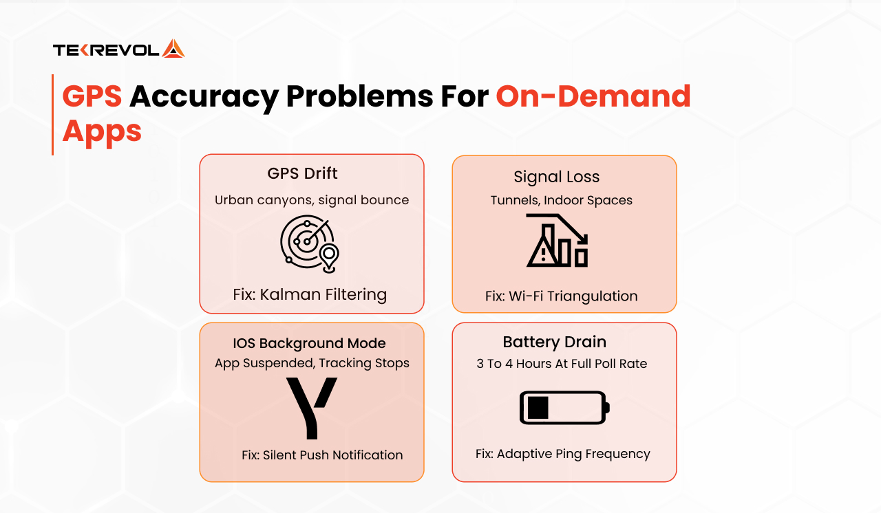
GPS Drift in Urban Environments
A stationary driver can appear to jump 20 to 50 meters on the map because of poor satellite geometry or multipath signal reflection from buildings. Users see the pin teleport and assume the driver is in the wrong location. Kalman filtering solves this by weighting recent location data against predicted movement direction, producing a smooth path that reflects actual movement rather than sensor noise.
Signal Loss in Tunnels and Indoor Spaces
GPS fails underground and indoors. Wi-Fi triangulation becomes the fallback, calculating position from signal strength across nearby access points and delivering 5 to 15 meters of accuracy inside buildings. When Wi-Fi is also unavailable, accelerometer data tracks movement direction and speed to estimate position during brief signal gaps. The app maintains tracking continuity even when no external positioning signal is available.
iOS Background Mode Restrictions
iOS suspends apps running in the background without explicit permission. A driver who switches to another app stops sending location updates unless you implement a silent push notification to wake the tracking process. This is one of the most common reasons tracking works in testing and fails in production. Test background mode behavior on physical iOS devices, not simulators, before launch.
Battery Drain From Continuous GPS Polling
Continuous GPS polling drains a device battery in three to four hours at high frequency. The fix is adaptive ping frequency: a driver moving at speed needs updates every 3 seconds, a parked driver needs updates every 30 seconds.
Using the Fused Location Provider on Android and batching requests significantly reduces power consumption without degrading the tracking experience.
How to Choose the Right Partner for a Real-Time Tracking Build
Most agencies can integrate a map view into an app. Far fewer have built a tracking system that holds up at 500 concurrent active drivers. Here is how you tell them apart.
Ask for a Live App Link
Find the app on the App Store or Google Play and open it. If a team has built live tracking at production scale, they can show you the app by name.
Ask for the Architecture Decision Document
A team that has done this before documents trade-offs before writing code: WebSocket vs polling, client-side v server-side geofence calculation, and battery drain mitigation approach. If they cannot show you that document, they have estimated without a plan.
Check for Multi-role Platform Experience
On-demand tracking serves at least two user types simultaneously. Building for concurrent roles with different data access is a different engineering challenge than building a single-user app. Ask directly whether they have done it.
Ask What Happens After Launch
Google Maps API pricing changes. iOS OS updates shift background mode behavior. Map SDK versions break existing functionality. A partner who hands over code and disappears leaves you managing those problems alone.
Look for a Phased Build Methodology
A team that only offers full-platform quotes is not thinking about your Phase 2 economics. A team that structures Phase 1 to make Phase 2 cheaper is thinking like a partner.
For a complete checklist of what separates strong partners from expensive mistakes, our guide on choosing the right on-demand app development partner covers every factor to evaluate.
Scope Your Real-Time Tracking On-Demand App With TekRevol
Adding Google Maps to your app does not give you real-time tracking. It gives you a map. The tracking layer, which includes WebSockets, queue architecture, and backend logic to broadcast coordinates, is the actual engineering challenge. Every component affects the next.
That’s why you need a partner with experience building live-tracking systems, not just integrating mapping APIs. TekRevol is a digital transformation company that has built live tracking across food delivery, social proximity, and multi-country logistics platforms.
We approach scalable custom on-demand apps with an understanding of the fundamentals: expected driver volume, update frequency, geofence complexity, and playback needs. Based on those requirements, we structure a discovery sprint where we run an architecture decision workshop before you commit to a full build.
Ready to Build a Scalable Real-Time Tracking Platform?
Talk to our team about a discovery sprint to validate your architecture, identify technical risks, before investing in a full-scale build.
Book Your Free Scoping Session


